|
c0|
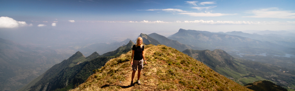
FAzja na lajcie 2013, Nepal, Trekking|
8dhaulagiri, himalaya, nepal, trekking
true, 'enclosing_element' => 'span'));*/ ?>
We were long wondering – even at the stage of planning a trip, a few months before coming to Nepal – which trekking to choose. We were considering only budget option, we wanted to spend as little as possible, which greatly limited the number of choices. In Nepal, in many regions (the so-called restricted areas), such as Dolpo, Manaslu, Makalu, or Kanchenjunga you can not legally organize trekking on your own – without the help of agencies, porters support and without nepali guide. Until now, restrictions have been lifted in the Annapurna region, Langtang and Solukhumbu (Everest). If you want to choose a less frequented area, you have to pay much more. Travelers whose objectives usually determines the budget, choose mostly trekking in Langtang or Everest region, a popular trail around Annapurna, or around – lying in her neighborhood – Dhaulagiri massif. We decided to do the latest of them for several reasons. This trekking is considered difficult, there are only a few people going there, and along the way, you can summit a simple trekking (officially classified by the Nepal Mountaineering Association as an expedition peak) six-thousand-er Dhamus Peak (6013 m).
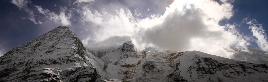
Locals warned us against extremely uncertain weather this season. This time they were right. Although the first days were sunny, bad weather came during the trekking. Conditions have changed dramatically. For four days it was snowing constantly. During the day, visibility was limited to just a few meters and there was a very strong wind. Despite this, still smoldering in us, there was the hope for a summit. However, after three cold bivouacs (at night temperature dropped below -20ºC), spent at the height of 5000m above sea level – in anticipation for better weather – changed our priorities. We wanted to get out of Hidden Valley and as soon as possible, before it completely spammed us here. The decision was good. In such conditions, in the snow to the calves, thighs, sometimes reaching waist, we were moving at an average of 1.5 km per hour. Paving to the same Dhampus Pass took us four hours and continuation to the Yak Kharka camp – another eight. This time the mountains gave us a pretty hard time. Well, after all, those are Himalayas ! :)
High in the mountains we met – to our surprise – no one. At the Dhaulagiri Base Camp there was no expedition, trekking agency, or any individual traveler. We only came across abandoned by the agency porters equipment: trekking and camping gear and also food supplies. Apparently, not only we tried to escape from the bad weather, from the White Mountain Dhaulagiri.
Practical info
- Trekking season in the Nepal Himalayas usually lasts from April to May and from October to the end of November. Trekking in Dhaulagiri region can be done in spring (it is warmer) or in autumn, in October. We went on a trek in November, and severe winter surprised us in the mountains. Regardless of the season – you need to be prepared for sudden changes in weather, in particular: snowfall, strong winds, poor visibility (called whiteouts) and low temperatures down to -25ºC. We recommend the trail around Dhaulagiri only to experienced and polished with winter conditions adventurers!
- For the trekking you will need – not counting getting to and from the trail – a minimum of 9 days (assuming you are moving fast and are already well acclimatized). For those acclimatizing only on the trail, we recommend an additional 3 days.
- “Around Dhaulagiri” map can be purchased at any bookstore, both in Kathmandu and Pokhara for about 400 NPR. The most accurate tourist maps are available at the scale of 1:85 000. The trekking route on the maps that we have seen, was mistakenly marked, so it’s not a real difference which map exactly we purchase.
- Before going on a trek it is necessary to obtain the necessary permits. The formalities should be best completed in Kathmandu, although it is also possible to do it in Pokhara. On the trek we take: TIMS card – Trekkers’ Management Information System ($20) and ACAP – ticket to the Annapurna Conservation Area Project (2000 NPR). Both of these documents can be obtained in one day in Kathmandu at Tourist Service Center (http://welcomenepal.com). If you plan other trekking after the Dhaulagiri in ACAP (Annapurna or Manaslu Circuit), you can try to keep the ticket, to use it – illegally – a second time. The only Check Post on route from Marpha to Beni is located in the village of Ghasa, all the buses stop there, usually there is a lot of confusion out there, however, and – if we have a little bit of cleverness – we can just not show the ticket to anyone.
- On the trek we take adequate supply of food, as well as a complete camping equipment.
Missing equipment can be easily bought in Kathmandu. We recommend the purchase of down – jackets 3500 NPR, sleeping bags, and trouser trekking around 2000 NPR (you have to remember, however, that these articles may be of dubious quality). - When it comes to grocery shopping – the most important advice – just not in stores in Thamel. There are both in Kathmandu and Pokhara branches of well-known supermarkets network such as Big Mart (http://www.bigmart.com.np/) and Bhat Bhateni Supermarket (http://www.bbsm.com.np/new/) where you can do a whole lot cheaper than shopping in the city for a longer trek. If you’re coming to Nepal from India and want to do shopping there – there is good supermarket network called Reliance Fresh (http://www.reliancefresh.info/). In Nepal, most goods are imported, in India you can buy the same products twice as cheap!
- Gas cartridges can be easily bought in tourist shops in Kathmandu or Pokhara (Primus 460g – 900 NPR). Fuel for gasoline stoves is significantly cheaper (1 liter of gasoline – 130 NPR) .
- The trekking route is not specially interesting. Trail running up the river Myagdi Khola is quite tedious, with painstaking ascends, and the road through the forest (we started from a height of 1100 m) extremely long. Nevertheless, trekking is very interesting in terms of sightseeing. Passes by many – untouched by tourist corruption – local villages. Initially, the route is easy to find and leads by frequented path through the villages. If in any doubt, you can ask locals for directions. Navigation difficulties may occur during passage through the French Pass and on route from Hidden Valley to Yak Kharka. It is useful – in our opinion, even necessary – to have GPS with route (you can use a GPX file from our trek, attached at the end of the post). In case of bad weather (heavy snow or whiteouts) mounds marking the route are invisible, and inaccurate paper map becomes useless for navigation. Thanks to the GPS device You can – despite the difficult conditions – safely go through the most difficult sections of the route, even if you move in deep snow, without waiting for the weather window.
- There is no need to take climbing gear to the trek, although there may be seasonal icing and for the comfort of hiking you can think about taking crampons.
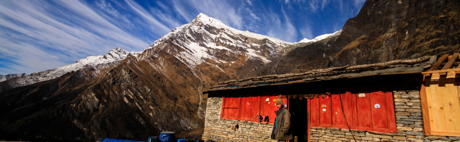
- The tourist infrastructure on the trail is poorly developed. In the villages during the first three days of trekking, you can stay for the night (homestay about 200 NPR / room), as well as get something to eat (the menu will be omelet, noodles, dal bhat). In the local shops with a small assortment you can buy instant soups (20 NPR) and cookies (15 NPR). The prices are not exorbitant, the higher, the more expensive. The last encampment inhabited by shepherds is Puchhar Base Camp (also known as Italian Base Camp), situated at an altitude of 3600m. In the shelter there you can do some last minute shopping (instant soup – 100 NPR, cookies – 100 NPR). In Marpha you can get virtually all varieties, but the prices are – as befits Annapurna – much higher (accommodation in a guest house – 300 NPR, breakfast – 350 NPR, lunch – 450 NPR) . Marpha os well known from products of apples: try the local apple juice (250 ml – 100 NPR), as well as delicious apple pie (200 NPR).
- On the trail there is no problem with communication in English. The locals are welcoming and helpful. More and more and more are willing to converse with tourists, especially local children who are learning English at school.
- On the way you will find many convenient locations for camping (sometimes you have to depart significantly from the villages to find a FREE, flat, secluded location, with access to water, however, usually it’s not a problem). Spending the night in shepherds camps such as Dobhan Kharka, Sallaghari (Jungle Camp) or Puchhar Base Camp, we have to be prepared for a fee equal to about 200 NRP / tenr. Of course, as everywhere – it’s worth to bargain!
- Since the trek leads up the river, along the way you have to overcome a whole lot of trail crossing streams. There is no lack of water anywhere and it is not needed to carry it with you (for us a small, half-liter bottle, repeatedly replenished in the course of the march was enough). On the trail we did not use any water purifiers, we used the side tributaries of the rivers and springs, located in the villages, and we didn’t have any stomach problems the entire way.
Approach
Trekking begins in Darbang and ends in Marpha. You can get to the villages using the local public transport without any problems.Getting to Darbang: In Pokhara, from the tourist district of Lakeside to the bus station (Bangalung Station) you can take a taxi for about 200 NPR. It would take us at least 40 minutes to do this on foot. Local buses to Beni run from 6.00 in the morning, every hour, till noon. The cost of the ticket is 220 NPR. The journey takes – with a long stopover on the way for lunch – about 6h. The alternative is to get a taxi, the cost is 4000-5000 NPR, but the journey takes only 3.5 hours From the main bus station in Beni You need to go – through the city about 15 minutes – to the bridge on the river Myagdi Khola. Minibuses to Darbang depart from the small square there (approximately four courses per day). The cost of the ticket is 200 NPR per person. Bus departs only when all the seats are occupied. The last bus leaves the Beni approximately at 17.00. Journey to Darbang takes 3 hours If you choose local transportation for travel from Pokhara to Darbang you should plan a whole day for it and don’t try to start trekking towards Dharapani. Darbang is quite large village, you can find a few guesthouses here (accommodation for 200 NPR), local eateries, and a whole bunch of well-stocked shops, pharmacies and service establishments.
Back from Marpha: From Marpha village, located directly on the popular trail leading around Annapurna, there are daily morning buses to Ghasa (leaving around 8am, ticket 700 NPR / person, the trip takes 3 hours). In Ghasaa you can catch, probably the same day, direct bus to Beni at a good price (the journey takes about 5 hours). From Beni to Pokhara and Kathmandu you can catch local bus from 6.00am (ticket to Pohkara 220 NPR / person). Our return trip took a full three days and consumed the greater part of our budget several days. We went to Nepal in the hot pre-election period, in November 2013. More about the difficulties of communication, as well as strike nine days before the election, you can read in our article on monoloco: http://www.monoloco.pl/podroze/nepal-demokracja-wybory-2013-fotoreportaz-artykul,
Detalied route description
The trail leads up the river Myagdi Khola through the magar villages to the base camp under the summit of Dhaulagiri, then through two high passes – French Pass (5380 m) and Dhampus Pass (5280 m) to Marpha – situated on the most popular trail leading around Annapurna. While preparing for trekking we used the information contained in the Polish guidebook “Around Annapurna and Dhaulagiri” by Janusz Kurczab (2011), as well as the descriptions and relations available at www.marek.bytom.pl and www.shangri.pl. While trekking route has slightly changed (the new trail was routed differently in some places) – we can recommend all these sources.Day 1 Darbang – Dar
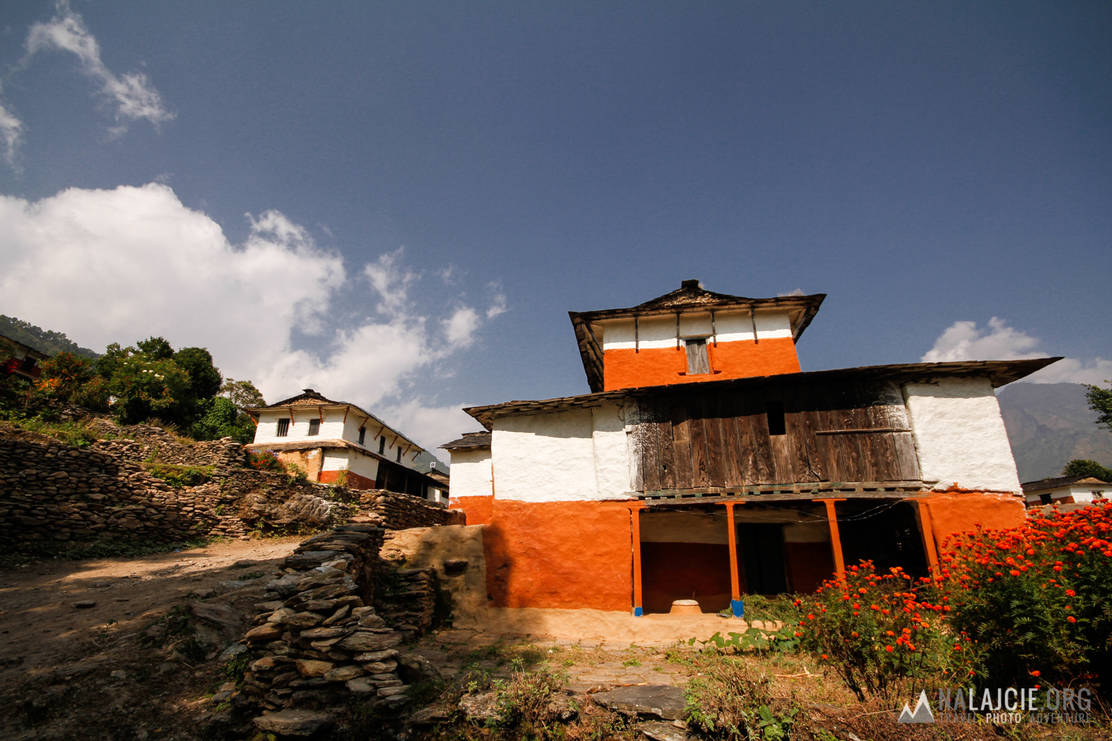
17km, 9h, 1400m elevation gain
From the center of Darbang (1100m) we go west gradually going down to the hanging bridge over the river. After crossing it, we turn right, and after a while enter the road. Irregular buses leave from here to Takam (using the transport can reduce the distance planned by more than a half). We go by the road to the next hanging bridge in Phedi (30min) and cross it. The road starts to climb up by wide switchbacks. We ascend by hiking trail in several places crossing the road, to the pass carved in the rock (1h 30min from Phedi , 1435m) and then traverse to Dharapani (45min, 1560m) – magar village with white and orange houses. We go through the village and further follow the road to Takam (1h 30min, 1660m). At the branch – just before the village – we choose the left (upper) path (in the village there is checkpost where TIMS card is required) and go through another cluster of houses – where we turn right from the main road. We continue to march to the next village – Sibang, in which we begin to ascend steeply (stone steps). After 20 minutes we arrive at a small saddle with a rest platform. Then, after 10min more we reach the branching pathway. Right path is a shortcut to the lower bridge at Dar Khola. We go straight ahead and climb steeply to the village Machim (2000m) to immediately go down to the first buildings of Phaliyagon (3h fromTakam, 1860m). We traverse them to the school, located on a ridge in the center of the village (you can find something to eat here and even stay for the night). Next we leave the village and head down (using one of the tracks) – towards the visible traversing route to the suspension bridge over the river Dar Khola (45min, 1780m). In the vicinity of the bridge – campsite.
From the center of Darbang (1100m) we go west gradually going down to the hanging bridge over the river. After crossing it, we turn right, and after a while enter the road. Irregular buses leave from here to Takam (using the transport can reduce the distance planned by more than a half). We go by the road to the next hanging bridge in Phedi (30min) and cross it. The road starts to climb up by wide switchbacks. We ascend by hiking trail in several places crossing the road, to the pass carved in the rock (1h 30min from Phedi , 1435m) and then traverse to Dharapani (45min, 1560m) – magar village with white and orange houses. We go through the village and further follow the road to Takam (1h 30min, 1660m). At the branch – just before the village – we choose the left (upper) path (in the village there is checkpost where TIMS card is required) and go through another cluster of houses – where we turn right from the main road. We continue to march to the next village – Sibang, in which we begin to ascend steeply (stone steps). After 20 minutes we arrive at a small saddle with a rest platform. Then, after 10min more we reach the branching pathway. Right path is a shortcut to the lower bridge at Dar Khola. We go straight ahead and climb steeply to the village Machim (2000m) to immediately go down to the first buildings of Phaliyagon (3h fromTakam, 1860m). We traverse them to the school, located on a ridge in the center of the village (you can find something to eat here and even stay for the night). Next we leave the village and head down (using one of the tracks) – towards the visible traversing route to the suspension bridge over the river Dar Khola (45min, 1780m). In the vicinity of the bridge – campsite.
Day 2 Dar – Boghara
16km, 10h 30min, 2000m elevation gain
After crossing the bridge we ascend towards the Dar village. After about 10min we reach the branching path with a tree nearby. We go by the right, less distinct path and traverse fields below the village. Soon we encounter descending trail from the Dar village, and after another 20 minutes the path from the lower bridge over the river Dar Khola. We continue to march for about 30min to get to Muri (shop). From the village we go by traverse, which lowers to the Mudi Khola river. At the height of the bridge we leave the main path to the right, steeply go downhill and cross it (1 hour from Muri, 1450m). Hence climb – quite steep traverse – to the distant saddle (1600m, 40 min). From the saddle we go down to the river Myagdi Khola (100m after the teahouse, at the fork of paths we can find a convenient place to bathe – indistinct path leads down to the hidden spring). Then we walk along the river, past the village Mahatala, until we reach the village of Naura (1495m, 4h from Muri). From Naura trail leads steeply up by switchbacks and gentle traverse towards rock ribs (exposure, grooved path in the rock). We are entering into the forest, in the distance you can see the first buildings of the village. Traverse little further (caution! branch – we choose the lower, less obvious path) and reach the Boghara (3h 30min from Naura, 2080m). There is well marked camping right on the trail.
After crossing the bridge we ascend towards the Dar village. After about 10min we reach the branching path with a tree nearby. We go by the right, less distinct path and traverse fields below the village. Soon we encounter descending trail from the Dar village, and after another 20 minutes the path from the lower bridge over the river Dar Khola. We continue to march for about 30min to get to Muri (shop). From the village we go by traverse, which lowers to the Mudi Khola river. At the height of the bridge we leave the main path to the right, steeply go downhill and cross it (1 hour from Muri, 1450m). Hence climb – quite steep traverse – to the distant saddle (1600m, 40 min). From the saddle we go down to the river Myagdi Khola (100m after the teahouse, at the fork of paths we can find a convenient place to bathe – indistinct path leads down to the hidden spring). Then we walk along the river, past the village Mahatala, until we reach the village of Naura (1495m, 4h from Muri). From Naura trail leads steeply up by switchbacks and gentle traverse towards rock ribs (exposure, grooved path in the rock). We are entering into the forest, in the distance you can see the first buildings of the village. Traverse little further (caution! branch – we choose the lower, less obvious path) and reach the Boghara (3h 30min from Naura, 2080m). There is well marked camping right on the trail.
Day 3 Boghara – Dobhan Kharka
11.5km, 8h 30min, 2500m elevation gain
We go down through the campsite to Jetlung – the last village in the valley. From here the trail leads steeply up towards the ribs visible above the village. There we reach the traverse going down to the river Myagdi Khola (2h from Boghara, 2025m, characteristic place – an old trolley river crossing). We continue the same path up the valley, gradually rising above its bottom. We cross a side stream below the series of cascades (single hut) and walking for 30min more to reach the Lipse meadows with two shepherd huts (1h from the trolley, 2100m). After that we still go in forest, sometimes traversing, sometimes ascending or going down steeply (caution! slippery – a lot of side streams) to get to Dobhan Kharka meadows (3h from Lipse, 2485m) with two teahouses (open only in high season) and good places for camping.
We go down through the campsite to Jetlung – the last village in the valley. From here the trail leads steeply up towards the ribs visible above the village. There we reach the traverse going down to the river Myagdi Khola (2h from Boghara, 2025m, characteristic place – an old trolley river crossing). We continue the same path up the valley, gradually rising above its bottom. We cross a side stream below the series of cascades (single hut) and walking for 30min more to reach the Lipse meadows with two shepherd huts (1h from the trolley, 2100m). After that we still go in forest, sometimes traversing, sometimes ascending or going down steeply (caution! slippery – a lot of side streams) to get to Dobhan Kharka meadows (3h from Lipse, 2485m) with two teahouses (open only in high season) and good places for camping.
Day 4 Dobhan Kharka – Puchhar BC
12km, 8h 30min, 2000m elevation gain
From the clearing head towards the bottom of the valley, where – using a suspension bridge – go to the other side of the river Myagdi Khola. We’re moving along her true left shore – sometimes traversing gently, sometimes approaching steeply – up the valley. After about 2 hours we cross the side valley with residual glacier, which we follow along the true right shore up, then enter back into the woods. After a further 2h 30min we arrive at Jungle Camp (5h from Dobhan Kharka, 3125m) – last campsite situated in the forest. We can stay here for the night, or – if we feel OK, and we have extra time – continue the march to Puchhar BC the same day. To do this, go through the side stream and climb the muddy moraine. We go up to the side valley, turn right into it and climb uphill on true left side of the stream. We cross the stream and ascend steeply by switchbacks up the hill to the exposed traverse to the left. Using the traverse we reach the ridge (1h 30min from Jungle Camp, 3440m), go up by it for 10 minutes until the gently sloping traverse the forest (clear path). Moving on, the forest turns into a loose scrub. After about 1h we cross the large side stream, and after a further 30min come to Puchhar BC, also called Italian BC (3-4h from Jungle Camp, 3610m, good camping sites, in the season open hut with tea and biscuits).
From the clearing head towards the bottom of the valley, where – using a suspension bridge – go to the other side of the river Myagdi Khola. We’re moving along her true left shore – sometimes traversing gently, sometimes approaching steeply – up the valley. After about 2 hours we cross the side valley with residual glacier, which we follow along the true right shore up, then enter back into the woods. After a further 2h 30min we arrive at Jungle Camp (5h from Dobhan Kharka, 3125m) – last campsite situated in the forest. We can stay here for the night, or – if we feel OK, and we have extra time – continue the march to Puchhar BC the same day. To do this, go through the side stream and climb the muddy moraine. We go up to the side valley, turn right into it and climb uphill on true left side of the stream. We cross the stream and ascend steeply by switchbacks up the hill to the exposed traverse to the left. Using the traverse we reach the ridge (1h 30min from Jungle Camp, 3440m), go up by it for 10 minutes until the gently sloping traverse the forest (clear path). Moving on, the forest turns into a loose scrub. After about 1h we cross the large side stream, and after a further 30min come to Puchhar BC, also called Italian BC (3-4h from Jungle Camp, 3610m, good camping sites, in the season open hut with tea and biscuits).
Day 5 Puchhar BC – Japan BC
9km, 6h, 1100m elevation gain
From the camp we go up gentle grassy slopes, and after about 20 minutes start to descent towards the left on the bottom of the valley glacier. The end of the descent leads by unpleasant, steep gully – it is best to pass this place early in the morning to minimize the risk of falling stones. We cross the glacier (covered with rubble rock, safe ), passing getting to the true right side of the valley – Myagdi Khola flows in this place deep under the ice. From the glacier we climb steeply uphill, then via exposed traverse below the rock wall we reach the extensive camping cave (1h from the glacier). Next we’re going uphill through grassy slopes to reach the Swiss BC (20min from the cave, 1h 45min from Puchhar BC, 3820m, a single hut). Before us lies the horizontal section of the valley, which we pass by going close to the true right bank of the river. Being near the place where the valley clearly turns to the right we start to climb steeply to enter the glacier Chhonbardan traversing from the left side (2h from Swiss BC, 4000m). We walk the path on the mud-pebble perch staying in the middle part of the glacier. After about 1h we reach Japan BC (4171m, platforms for the tents, water from the pool – the path to the south of the camp).
From the camp we go up gentle grassy slopes, and after about 20 minutes start to descent towards the left on the bottom of the valley glacier. The end of the descent leads by unpleasant, steep gully – it is best to pass this place early in the morning to minimize the risk of falling stones. We cross the glacier (covered with rubble rock, safe ), passing getting to the true right side of the valley – Myagdi Khola flows in this place deep under the ice. From the glacier we climb steeply uphill, then via exposed traverse below the rock wall we reach the extensive camping cave (1h from the glacier). Next we’re going uphill through grassy slopes to reach the Swiss BC (20min from the cave, 1h 45min from Puchhar BC, 3820m, a single hut). Before us lies the horizontal section of the valley, which we pass by going close to the true right bank of the river. Being near the place where the valley clearly turns to the right we start to climb steeply to enter the glacier Chhonbardan traversing from the left side (2h from Swiss BC, 4000m). We walk the path on the mud-pebble perch staying in the middle part of the glacier. After about 1h we reach Japan BC (4171m, platforms for the tents, water from the pool – the path to the south of the camp).
Day 6 Japan BC – Dhaulagiri BC
6.5km, 5h, 850m elevation gain
From the Japan BC we continue up the valley (path, mounds). We stick to the middle of the Chhonbardan glacier, using the mud-rocky moraines. After about 2h 30min we ascend a significantly higher moraine (prayer flags), and after a moment descend to the part of the glacier covered with snow (note – crevase). We head further up until the North-East Col Icefall (the normal route to Dhaulagiri leads that way), where we go to the left side moraine of the glacier with clearly visible bivouac places. About 30 minutes further up the moraine (path, mounds) there is Dhaulagiri Base Camp (4700m, platform under the tent, plaques, daytime water flows on the surface of the glacier), which is more sheltered from the wind. From the base perfectly visible is powerful, two thousand meter high, north-eastern wall of Dhaulagiri – the so-called Eiger wall.
From the Japan BC we continue up the valley (path, mounds). We stick to the middle of the Chhonbardan glacier, using the mud-rocky moraines. After about 2h 30min we ascend a significantly higher moraine (prayer flags), and after a moment descend to the part of the glacier covered with snow (note – crevase). We head further up until the North-East Col Icefall (the normal route to Dhaulagiri leads that way), where we go to the left side moraine of the glacier with clearly visible bivouac places. About 30 minutes further up the moraine (path, mounds) there is Dhaulagiri Base Camp (4700m, platform under the tent, plaques, daytime water flows on the surface of the glacier), which is more sheltered from the wind. From the base perfectly visible is powerful, two thousand meter high, north-eastern wall of Dhaulagiri – the so-called Eiger wall.
Day 7 Dhaulagiri BC – Hidden Valley
10km, 8h, 1100m elevation gain
We leave the Dhaulagiri BC and go by the path leading up the moraines on true right side of the valley. At the height of Tukuche Icefall wedescend to the glacier (45min from Dhaulagiri BC) to get close to the high moraine clearly standing in the middle of the valley. We climb up to it from the right side (1h 30min from Dhaulagiri BC, 4960m, mounds). Then we ascend by the ridge to the two large stone mounds (1h 40min, 5245m). We leave the ridge there, we turn left and go down a little, then climb gentle slopes upward, toward the distant French Pass (1h from mounds , 4 -5h from Dhaulagiri BC, 5381m, prayer flags). From the pass we descend traversing to the right – we need to climb the moraine obstructing access to the Hidden Valley (1h 30min from French Pass). The river flows in the middle of the valley, there are a lot of good camping sites, even so it is worth to get as close to the Dhampus Pass as possible – we shorten the distance that we have to walk the next day. By the ridge descending from Tukuche Peak (visible from afar) we can find places for tent sheltered from the wind (2h 30min from French Pass, 5090m, chorten, prayer flags).
We leave the Dhaulagiri BC and go by the path leading up the moraines on true right side of the valley. At the height of Tukuche Icefall wedescend to the glacier (45min from Dhaulagiri BC) to get close to the high moraine clearly standing in the middle of the valley. We climb up to it from the right side (1h 30min from Dhaulagiri BC, 4960m, mounds). Then we ascend by the ridge to the two large stone mounds (1h 40min, 5245m). We leave the ridge there, we turn left and go down a little, then climb gentle slopes upward, toward the distant French Pass (1h from mounds , 4 -5h from Dhaulagiri BC, 5381m, prayer flags). From the pass we descend traversing to the right – we need to climb the moraine obstructing access to the Hidden Valley (1h 30min from French Pass). The river flows in the middle of the valley, there are a lot of good camping sites, even so it is worth to get as close to the Dhampus Pass as possible – we shorten the distance that we have to walk the next day. By the ridge descending from Tukuche Peak (visible from afar) we can find places for tent sheltered from the wind (2h 30min from French Pass, 5090m, chorten, prayer flags).
Day 8 Hidden Valley – Yak Kharka
12km, 10h, 900m elevation gain
From the bivouac place with chorten we’re climbing a small ridge descending from Tukuche Peak, cross it at an angle to the right (mounds) and descend to the side valley. Then we ascend slopes on the opposite side and start traversing to the left toward the visible Dhampus Peak. After about 2 hours we reach Dhampus Pass (5280m). We can enjoy the views: Annapurna group of Nilgiri range in the foreground and Annapurna I behind them, Tukuche Peak (directly on the south), Dhampus Peak and the panorama of the entire Hidden Valley. From the pass the road leads traverse keeping to the true left side of the valley (mounds). At the beginning it is lowering, then for a long time remains at the same altitude. Be careful not to start going down towards the river Dudhepani Khola, because many slopes end in cliffs and the river itself flows into the Khali Gandaki well below the village of Marpha. After about 4 hours we reach a clear ridge, by which we’re descending, using the running zigzag path. In the meadows on the left side below the ridge, we can see a single hut with silver-black roof – the Yak Kharka camp (4180m, a new hut for hikers built in 2013). Continuing the march on the ridge we would get to Tukuche, instead we descend to the left at a height of two distinct mounds (1h from the entrance to the ridge) and go steep rocky-grass slope (without path) towards the visible hut (1h). Where are good camping sites surrounding the building at Yak Kharka.
From the bivouac place with chorten we’re climbing a small ridge descending from Tukuche Peak, cross it at an angle to the right (mounds) and descend to the side valley. Then we ascend slopes on the opposite side and start traversing to the left toward the visible Dhampus Peak. After about 2 hours we reach Dhampus Pass (5280m). We can enjoy the views: Annapurna group of Nilgiri range in the foreground and Annapurna I behind them, Tukuche Peak (directly on the south), Dhampus Peak and the panorama of the entire Hidden Valley. From the pass the road leads traverse keeping to the true left side of the valley (mounds). At the beginning it is lowering, then for a long time remains at the same altitude. Be careful not to start going down towards the river Dudhepani Khola, because many slopes end in cliffs and the river itself flows into the Khali Gandaki well below the village of Marpha. After about 4 hours we reach a clear ridge, by which we’re descending, using the running zigzag path. In the meadows on the left side below the ridge, we can see a single hut with silver-black roof – the Yak Kharka camp (4180m, a new hut for hikers built in 2013). Continuing the march on the ridge we would get to Tukuche, instead we descend to the left at a height of two distinct mounds (1h from the entrance to the ridge) and go steep rocky-grass slope (without path) towards the visible hut (1h). Where are good camping sites surrounding the building at Yak Kharka.
Day 9 Yak Kharka – Marpha
7.5km, 3h 30min, 100m elevation gain
From Yak Kharka we follow a clear path, traversing the grassy slopes to the ridge visible in the distance on the left. Going down past the trees, we’re passing village Alu Bari (3760m, 1h 30min from Yak Kharka), and a moment later Khali Gandaki valley view point – the road leads around a rocky cliff on the ridge from here (and not directly into the valley). Then we begin the long and arduous steep descent using switchbacks. Approx 100m above the valley floor the path traverses again, reaching Marpha view point (1h 30min from Alu Bari). Next we go down among the dried mud gorges and enter the village close to the main road at the height of the “Dhaulagiri Base Camp” signpost (20min, 2680m, shops, hotels, bus stop).
From Yak Kharka we follow a clear path, traversing the grassy slopes to the ridge visible in the distance on the left. Going down past the trees, we’re passing village Alu Bari (3760m, 1h 30min from Yak Kharka), and a moment later Khali Gandaki valley view point – the road leads around a rocky cliff on the ridge from here (and not directly into the valley). Then we begin the long and arduous steep descent using switchbacks. Approx 100m above the valley floor the path traverses again, reaching Marpha view point (1h 30min from Alu Bari). Next we go down among the dried mud gorges and enter the village close to the main road at the height of the “Dhaulagiri Base Camp” signpost (20min, 2680m, shops, hotels, bus stop).
Track can be downloaded as KML or GPX.